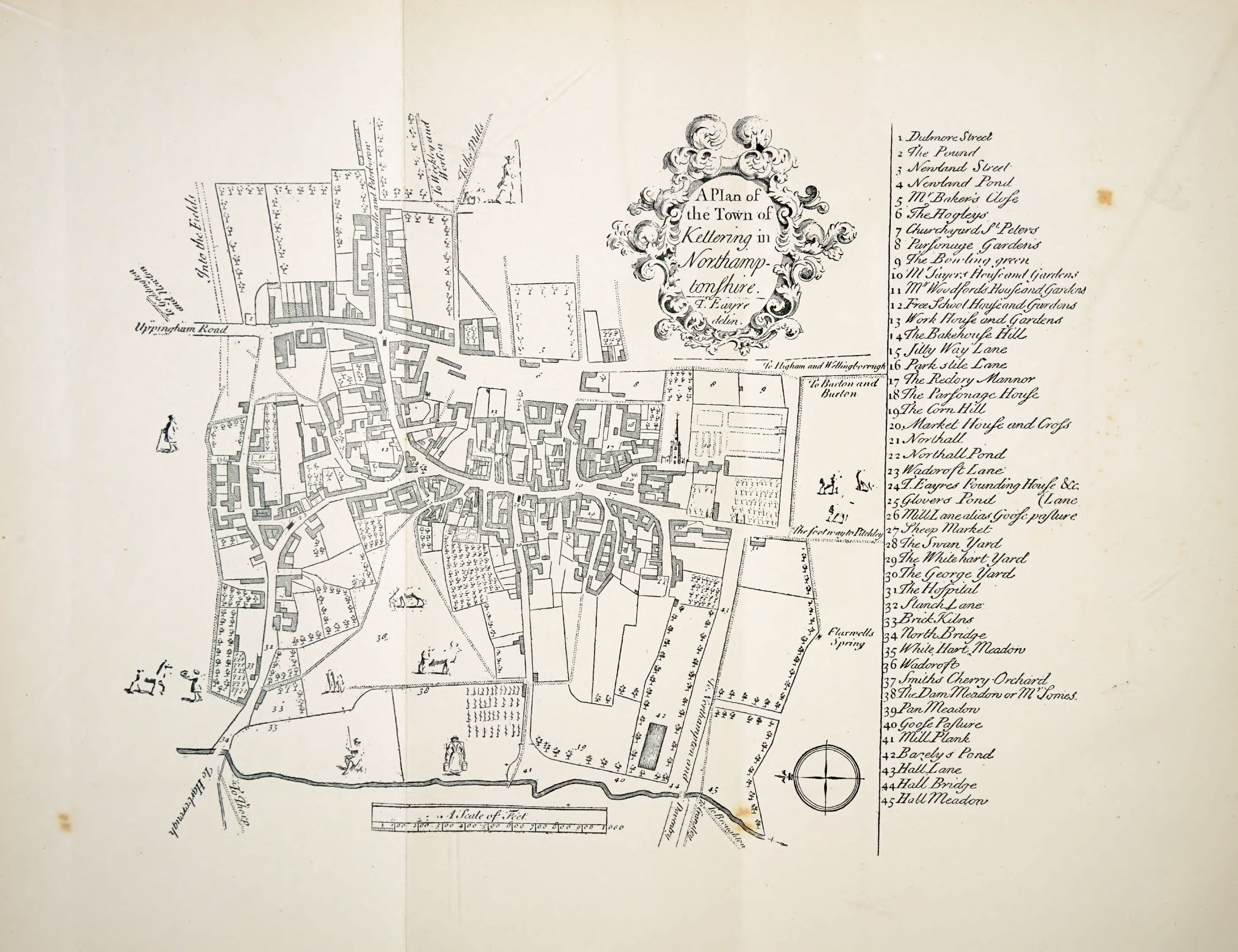
Each point includes a quick “then and now” summary plus the key historical note.
1. Dulmore Street (now Montagu Street)
Then: Dulmore Street (likely Dunmore)
Now: Montagu Street
The name likely drifted from “Dunmowes Peece” (1587) to “Dunmore”, with Eayres misspelling it as “Dulmore”. Later it became Swan Street after the Swan Inn,
and then Montagu Street for the Montagu family of Boughton House. Eastwards it becomes Stamford Road.
2. The Pound
Then: Livestock pound
Now: Near Eskdaill Street and Rockingham Road
A communal holding pen for stray livestock, overseen by the pinder who collected fines. Pounds are medieval in origin and typically sat at prominent junctions.
Earlier mapping places an older pound further out, around the modern Telford Way Industrial Estate.
3. Newland Street and the Newlands
Then: Newland
Now: Newland Street
“Newlands” appear as early as 1292 and show early expansion beyond the market place. A 1405 document describes two rows of tenements,
one facing what is now Montagu Street and the other facing the future Rockingham Road. In Victorian times it was Fleur-de-Lis Street.
4. Newland Pond
Then: Horse-washing pond
Now: Top of modern Gold Street area
A horse-washing pond with a stone cross set into one wall. Crossroads ponds were essential stopping points: water, rest, and a landmark.
5. Mr Baker’s Close
Then: Enclosed field (close)
Now: Near Earl of Dalkeith pub site
A “close” is an enclosed field. Vestry entries from 1713 to 1723 mention a Joseph Baker, likely behind the name.
It fronted onto the Hogleys near the site of the Earl of Dalkeith public house.
6. The Hogleys
Then: Pig pasture, later animal trading
Now: Horsemarket area
Began as pasture for pigs, later the town’s animal trading area. Part became Horsemarket. Stocks were moved here from the Market Square.
The map shows School Lane and Job Roughton’s yard (Job’s Yard).
7. St Peter and St Paul’s Churchyard
Then: Churchyard extended to London Road
Now: Churchyard by St Peter and St Paul’s
The church has stood here since at least 1125. In 1721 the churchyard extended east to what is now London Road.
The main entrance was via the north door rather than the west gate on Sheep Street.
8. Parsonage Gardens
Then: Parsonage Gardens
Now: Police station and swimming pool car park area
Land flanking the churchyard on both sides, now occupied by the former police station site and the swimming pool car park.
9. The Bowling Green
Then: Bowling Green
Now: Bowling Green Road area
A recreation space shown on London Road. By the 19th century it became Drovers Hall and the Cattle Market. The name survives in Bowling Green Road.
10. The Manor House (Mr Sayers / Sawyer)
Then: Sawyer manor house and gardens
Now: Manor House Museum site
Eayres labels the great house of Mr Sayers, actually the Sawyer family, lords of the manor for 150 years. The Manor House Museum stands here today.
Beneath it lay the medieval abbot’s hall (1233 to 1246) and associated grange landscape, later reshaped into formal gardens.
11. Mr Woodford’s House
Then: Mr Woodford’s House
Now: Adjoining manor and parsonage grounds area
Likely linked to Thomas Woodford (died 1723). Shown as a substantial house with gardens next to the manor and parsonage grounds.
12. Free School House
Then: Grammar School (founded 1577)
Now: Building lost in redevelopment
Founded in 1577, this served as Kettering’s grammar school until 1913. It survived until the 1960s when it was demolished during town centre redevelopment.
13. Workhouse and Workhouse Lane
Then: Workhouse (1718 to 1720)
Now: Dryland Street area
The original workhouse was built 1718 to 1720 for £180. The adjacent lane became Workhouse Lane, later Dryland Street.
A new workhouse on London Road replaced it in 1837.
14. Bakehouse Hill
Then: Bakehouse at its foot
Now: Part of Gold Street by the clock monument
Named for the bakehouse at its foot. Later buildings came and went. Today the site is marked by Kettering’s clock monument and forms part of modern Gold Street.
15. Jitty Way Lane
Then: Jitty Way Lane
Now: Dryland Street line
“Jitty” means a narrow passage. This may be one of the earliest recorded uses. The lane later became Workhouse Lane and finally Dryland Street.
16. Park Stile Lane
Then: Park Stile Lane
Now: Market Street
Probably the northern edge of the early market square. Renamed Market Street in the mid 19th century.
17. The Rectory Manor
Then: Rector’s estate and court
Now: East side of market place footprint
The Rectory Manor was separate from the secular manor and had its own court. It existed by the 13th century and by 1405 had tenements along the east side of the market place.
After the Dissolution, it was leased to the Watsons until 1802. The medieval Rectory House was later demolished.
18. The Parsonage House
Then: Parsonage House
Now: Near church (one shield survives)
Close to the church with a gateway decorated with the shields of St Peter (keys) and St Paul (sword). One shield survives set into a garden wall of the modern rectory.
19. Corn Hill
Then: Corn Hill
Now: By the market place
An important trading spot at the foot of Park Stile Lane, by the market place.
20. Market House, Market Cross and Rotten Row
Then: Market House and Cross
Now: Market place area
The market dates to 1227. The Market House (1629) was demolished in 1805. The Market Cross once had a dungeon beneath; later replacements were removed in the early 1800s.
Rotten Row ran along the western edge and divided the Sheep Market from Butchers Row before being demolished in the late 1700s.
21. Northall
Then: Substantial house
Now: Where Lower Street meets Northall Street
A substantial house once stood where Lower Street meets Northall Street today.
22. Northall Pond
Then: Northall Pond
Now: Infilled in the 19th century
The pond survived until 1831 when the vestry ordered it filled in, calling it a nuisance.
23. Wadcroft Lane
Then: Wadcroft Lane
Now: Shrunk lane returning to High Street
Recorded as early as 1527. The 1587 map shows it leading towards the north bridge area; by 1719 it had shrunk into a semicircular lane returning to the High Street.
24. Thomas Eayre’s Foundry and Bellfoundry Lane
Then: Foundry off the High Street
Now: Bellfoundry Lane
Eayre cast more than 200 bells, including those of St Peter and St Paul in 1733. His foundry stood off the High Street on the lane now called Bellfoundry Lane.
The sign still survives. He lived on Gold Street.
25. Glovers Pond
Then: Pond and medieval cross
Now: High Street and Mill Lane junction area
Glovers Pond stood at the junction of High Street and Mill Lane, once marked by a medieval cross. By 1808 it was known as Goosepasture Lane Pond and considered a health problem.
Vestry resolutions called for it to be filled in during the early 1800s.
26. Mill Lane (Goosepasture Lane to Gas Street to Meadow Road)
Then: Mill Lane
Now: Meadow Road
Recorded by 1405. A mill once stood at its foot, powered by a mill pond mentioned in 1321. The adjacent pasture gave the lane the name Goosepasture Lane.
With the arrival of the gasworks it became Gas Street, now Meadow Road.
27. Sheep Market
Then: Sheep Market
Now: Sheep Street area
Separated from the market place by Rotten Row, this area later became Sheep Street, reflecting its long association with sheep trading.
28. Swan Yard
Then: Swan Inn yard
Now: Montagu Street area
The Swan Inn was a major local coaching inn and its yard became a key hub for travellers, meetings and deliveries. The inn also gave its name to Swan Street (later Montagu Street).
29. White Hart Yard
Then: White Hart
Now: Royal Hotel site
The White Hart hosted vestry meetings and later took the name “Royal” after Queen Victoria and Prince Albert visited in 1844.
30. The George Yard and Cock Lane
Then: Cock Lane by the George
Now: George Street area
George Street was once Cock Lane, named after the Cock Inn (recorded 1639). Archaeological hints suggest habitation here back to at least 1292, including tenements held by the town’s acremen.
31. The Hospital (Almshouses)
Then: Almshouses built 1688
Now: Inscription survives
Built in 1688 with money from Henry Sawyer, who died in Aleppo. The inscription survives on the wall today.
32. Staunch Lane
Then: Staunch Lane
Now: Lower Street
The old name for Lower Street and the road to Rothwell. “Staunch” refers to a powdered stone used to stop bleeding.
33. Brick Kilns
Then: Brick kilns
Now: Northfield Road retail area
Brick kilns once sat on the north side of Staunch Lane (Lower Street), stretching down toward Broomhill, across what is now the Northfield Road retail area.
34. North Bridge
Then: Stone bridge over Slade Brook
Now: Northfield Avenue roundabout area
A small stone bridge near today’s major roundabout where Northfield Avenue, Rothwell Road and Lower Street meet. It was a key crossing point in 1721.
35. White Hart Meadow
Then: Meadowland west of centre
Now: Approximate western meadows
The old maps are vague, but it sat in meadows west of the centre and was likely linked to grazing rights and the White Hart’s sphere of influence.
36. Wadcroft
Then: Woad growing land
Now: Commercial Road car park area
First mentioned in 1292. A hedged croft where woad (“wad”) was grown for blue dye, supporting the woollen trade.
It stayed common land until the 1801 Enclosure Act. Today it is around the Commercial Road car park and nearby streets.
37. Smith’s Cherry Orchard
Then: Cherry orchard
Now: Commercial Road and Meadow Road area
An orchard once covering the ground now occupied by Commercial Road and Meadow Road, beside Wadcroft.
38. Dam Meadow (Mr Somes’s Meadow)
Then: Tenter rows for cloth
Now: West of Wadcroft line
The map shows long rows of tenters, meaning the meadow was used to stretch, dry and bleach cloth, tying into the woad and woollen working landscape.
39. Pan Meadow
Then: Pan Meadow
Now: Westfield Gardens area
Stood at the far western end of Mill Lane, where Westfield Gardens is today.
40. Goose Pasture
Then: Pastureland
Now: Mill Lane environs
Pastureland that gave the lane its older name Goosepasture Lane.
41. Mill Plank
Then: Plank crossing
Now: Bottom of Mill Lane area
A plank crossing over the Slade Brook at the bottom of Mill Lane. A mill is recorded here in 1405 but gone by 1488, leaving the plank and place names as memory.
42. Bazely’s Pond
Then: Manor pond
Now: Along the Northfield Avenue line
Just east of Goose Pasture, roughly where Northfield Avenue runs now. It belonged to the manor. The name “Bazely” remains uncertain.
43. Hall Lane (now Northampton Road)
Then: Hall Lane
Now: Northampton Road
Named after the grand Manor Hall complex (built around 1233, demolished in the 16th to 17th century). The lane survives as Northampton Road.
44. Hall Bridge
Then: Bridge at the bottom of Hall Lane
Now: Northampton Road crossing line
A bridge crossing the Slade at the bottom of Hall Lane, preserving the memory of the manor hall landscape.
45. Hall Meadow
Then: Hall Meadow
Now: Thurston Drive and Lake Avenue area
Meadowland named from the vanished hall. Today it relates to the area around Thurston Drive, Lake Avenue and the surrounding estate.